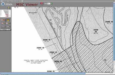
Two weeks ago, Coastal Connection received this inquiry from a reader in Fort Myers, Florida: “Do you have any information regarding any adjustments that are anticipated to the FIRM maps in Florida, specifically in Sarasota County?” We didn’t, so we contacted Desiree Companion, a Certified Floodplain Manager with unincorporated Sarasota County whose duties include community outreach and education about flood plain mapping. Companion told us that indeed, Sarasota County, like most other flood-prone communities throughout the United States, is participating in the nationwide effort by the Federal Emergency Management Agency (FEMA) to replace the old system of paper-based flood zone maps with new “Digital Flood Insurance Rate Maps,” or DFIRMs. Throughout the country, said Companion, FEMA’s old paper maps are overdue for an upgrade. Many of them have not been updated for many years, even as conditions on the ground have changed. Even when they were new, she said, the margin of error of some older maps was typically as great as 250 feet. Modern aerial mapping methods, using laser measurements and computer modeling, have created the opportunity for much more accurate maps, while Web technology has provided the means to make those maps readily available to the public. From 2004 to 2008, FEMA worked to collect and organize new geographic map data. Now, the plan is to present all the new data in the form of a national DFIRM database, accessible through the Internet. FEMA’s website publishes details of the agency’s “Risk MAP” program. Publication schedules for the revised digital maps vary from place to place. In Sarasota County, Companion said, provisional maps reflecting new topographic data for Sarasota County will be ready for public review and comment by May 31, 2010. After review, the on-line, searchable version of the new map should be published in 2011. The Sarasota County website has posted a status report on the effort. But throughout the country, said Companion, FEMA’s national web pages already let the public view the latest official flood rate maps and learn the status of flood map revisions for any address. At FloodSmart.gov, the official site of the National Flood Insurance Program (NFIP), you can check the schedule for the flood map revision process in any ZIP code. And for a quick report on the official flood risk for any given location, you can enter the address in the box on the left-hand side of the page (remember to check whether the property is commercial or residential). FEMA has stopped selling paper copies of its old Flood Insurance Rate Maps. Instead, the agency now has an online “Map Service Center” where you can look up the digital versions and print what the agency calls a “FIRMette.” However, most searches don’t turn up one of the new high-tech interactive digital maps. Instead, what you’ll probably see when you enter an address is a scan of an old paper map.
Currently, a scan of the most recent paper map is the likely result of an online search of FEMA’s Map Service Center. This example was the result of a search for the White Elephant Pub, on the water at 1855 Gulf Boulevard, Englewood, Fla. But online scans of old paper maps are a temporary mid-point in the transition to digital flood maps. Within a few years, FEMA’s servers will be displaying what some localities already provide: updated digitized topographic data stored in Geographic Information System (GIS) format, and displayed as an interactive map. Charlotte County, Florida, for example, has an interactive map server in place at www.ccgis.com. When we searched for the White Elephant Pub by the water on Gulf Boulevard in Englewood, Florida, Charlotte County served up this photo map, complete with a link to county property records.
Some localities already provide updated digitized topographic data stored in Geographic Information System (GIS) format. This interactive version from Charlotte County Fla. displays the area around the White Elephant Pub (red area) on Gulf Blvd. The check boxes activate different map features, including the an overlay of the most current FEMA flood zone data, which overlays the VE storm surge zone and the AE flood zone in red and blue, respectively, on the aerial photo. A click on the account number in the pop-up window displays not just the flood zone designation, but the Base Flood Elevation (BFE) for the site. In our sample search for the White Elephant Pub, we also got information about whether the property is in an undeveloped “COBRA Zone,” where the Coastal Barrier Resources Act prohibits coverage with NFIP insurance (it’s not), and whether there has been a Letter of Map Revision (LOMR) filed for that location to contest its flood designation (there hasn’t).
Digitized topographical maps also display current flood zone overlays. This example shows the VE storm surge zone in red and the AE flood zone in blue overlaid on the map of the Gulf Blvd. address of the White Elephant Pub. Other local governments are serving up similar interactive maps. The Cape Cod town of Chatham, Massachusetts, for example, uses the Mapsonline website created by a company called PeopleGIS to post an interactive digital map that includes FEMA’s proposed flood map revisions. Using the “Layer” buttons provided in the side window, viewers can turn flood-zone data on or off, and can also view other layers, including aerial photo information from 2005. Shore features, obviously, change from year to year — as do flood plains near active rivers. FEMA’s plan is to review and modify its digital map data routinely. And the agency invites any owner who doesn’t agree with the flood hazard designation of a property to apply for a Letter of Map Revision. If the evidence is strong enough, says FEMA, the requirement for flood insurance can be waived on a site-by-site basis — and the maps will be revised to reflect the change.