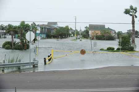
Rising water began to block roads near Galveston, Texas, far in advance of Hurricane Ike’s landfall and official storm surge. Photo courtesy Jocelyn Augustino/FEMA More than a year after Hurricane Ike made landfall near Galveston, Texas, some scientists are still puzzling over one of the storm’s unusual traits — rising water that flooded some parts of the Texas coast far in advance of the storm’s anticipated surge. “There’s something called a forerunner that isn’t showing up in any of the computer models,” North Carolina Sea Grant storm flooding expert Spencer Rogers told Coastal Connection in November. The forerunner wave appears to have caused Ike’s high water to arrive earlier, stay longer, and cause more damage than was otherwise expected. The early flooding may also have contributed to Ike’s tragic fatalities. That’s because some residents who had planned to evacuate low-lying areas ahead of the storm found their escape routes blocked much earlier than they had anticipated. Unable to make their way to safety, some of the locals became victims of the storm: trapped, swept away, and drowned when the main surge and its punishing waves did arrive. “It was actually flooded on the Bolivar Peninsula for over 20 hours,” says Rogers. “The flooding came in way early. Normally, four or five hours would be a long period for peak flooding. But that early wave flooded everything, so people couldn’t get off the island — 24 hours in advance, practically.”
A few days after the storm, USA Today told the story of Texas builder Bobby Anderson, who was trapped with a woman friend in Gilchrist on the Bolivar Peninsula, when the two found their way blocked by four feet of water on the highway in early afternoon (” Man stricken with loss when rescue never came,” by Allen G. Breed, AP National Writer). The pair took refuge in the upper floors of a partially built house — but Anderson’s companion lost her grip on the house’s rafters during the night and was washed away. Officially, Hurricane Ike made landfall as just a Category 2 hurricane on the Saffir-Simpson scale — a fact that deceived some coastal residents into underestimating the force and fury of the storm’s accompanying surge. But weather scientists were aware well in advance that Ike’s surge was sure to exceed the typical wave brought by a Category 2 storm. Ike’s peak winds were only part of the equation, they pointed out: the very wide area covered by the storm meant that the energy in the water wave it created was likely to be devastating. Expert Jeff Masters, PhD., for instance, warned on his Weather Underground blog, “The amount of water Ike has put in motion is about 10% greater than what Katrina did, and thus we can expect Ike’s storm surge damage will be similar to or greater than Katrina’s.” And official government warnings minced no words: “ALL NEIGHBORHOODS…AND POSSIBLY ENTIRE COASTAL COMMUNITIES… WILL BE INUNDATED DURING THE PERIOD OF PEAK STORM TIDE. PERSONS NOT HEEDING EVACUATION ORDERS IN SINGLE FAMILY ONE OR TWO STORY HOMES WILL FACE CERTAIN DEATH.” This YouTube archive of Associated Press coverage before Ike’s arrival shows Texas officials telling residents, ” Get off the roads now“. It was all very clear and direct — except that neither Dr. Masters’ scholarly discussion nor the Weather Service warnings made mention of any early-arriving wave. In fact, scientists did not expect the early-rising water — and it took months after the storm before they were sure that the “forerunner wave” had happened at all. Historically, says Spencer Rogers, researchers have not had good information on storm surges. “We never had any data,” he explains. “In storm surges, all the tide gauges fail.” But starting with Hurricane Rita, he says, U.S. Geological Survey scientists have been placing special metering devices in the path of oncoming storms. “These are simple, small pressure gauges that they tie to something that they think is going to be there after the storm,” he says. “And it’s like the wind towers people set up in front of the storms — sooner or later you are gonna get lucky, and we did get lucky for Ike. There were a few gauges that survived Ike, and right in the middle of our study area, we know what the water level was. I can tell you that it was 20 hours, because we have a gauge recording of it. And that, we have never had in earlier storms. So now that we can see it, and prove what happened, we can go back in and try and figure out how we would identify it in advance, and maybe do some predictions. But putting it into a storm surge model is much harder and more complicated. That’s a lot more years down the line.” Even the cause of the wave is a mystery, says Rogers. “One theory is that it’s a wave generated internally within the gulf, that is rotating around the Gulf of Mexico, driven by a Gulf-of-Mexico-scale hurricane effect. The hurricane coming into the gulf would initiate it [watch this satellite time-lapse video of Ike moving into the Gulf and across to Texas]. But for that rotating wave to be a problem, that has to hit at the target area at the same time that the storm does. So if they’re out of sync, it may not be a factor.” Until meteorologists and oceanographers get a better handle on the dynamics of the phenomenon, anticipating hurricane flooding and wave effects will remain more of an art than a science. In South Louisiana, Ike brought not just an early surge, but also a “second surge,” reports the Baton Rouge Advocate (“Second surge hidden hazard of hurricanes,” by Amy Wold). There, Port Fourchon Harbor Police Chief Jon Callais told the Advocate, crews planning to evacuate municipal trucks were surprised by two feet of floodwater on the highway more than 36 hours before Ike made landfall — and the hurricane did not even pass over the area. Other residents evacuated, then returned when water receded — only to have to leave a second time when rising water returned. The forerunner effect is an exception, notes Spencer Rogers, and may not even occur with Atlantic Coast hurricanes. “It’s in no way typical,” Rogers says. “Where I live in North Carolina, I was in the eye of four hurricanes between 1996 and 1999, and then in the radius of maximum winds for a fifth one. We were close enough to the target areas that we got good measurements of storm surge rise and fall, in my backyard. And none of those storms had a forerunner. This is not something that occurs every single time.” But for Gulf Coast residents, the forerunner threat is a good reason to heed evacuation warnings — and to heed them early. And it’s yet one more reason why in coming decades, low-lying areas near the Gulf are likely to face increasing pressure from flood and erosion, as well as from storm winds.