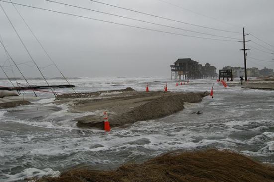

Wind and surf pound the highway and utility lines at N.C. 12’s…
Hurricane Sandy didn’t make a direct hit on the North Carolina Outer Banks. But even the storm’s grazing near-miss was enough to cut the main access road to the further-out islands, North Carolina state highway 12. Follow-on nor’easters continued to pound the Banks throughout the winter, challenging the North Carolina Department of Transportation’s efforts to restore highway service to island communities such as Rodanthe.
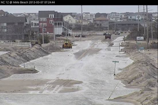
This spring, N.C. 12 has been looking iffy. That’s a problem of daily life for full-time residents of the barrier islands—and by threatening the seasonal tourist traffic that is the region’s life blood, it also endangers the health of their local economy. The Raleigh News & Observer has this report: (“Road Worrier: Along the Outer Banks, NC DOT battles the sea,” by Bruce Siceloff). “The sun was shining Monday [March 11] along the Outer Banks, but N.C. 12 was under water at places up and down the coast. Part of the channel across Hatteras Inlet was choked with sand, and the state’s busiest ferry route ran on a limited schedule … In the wake of a winter storm last week that flushed water and sand across the barrier islands, N.C. 12 has been impassable—for hours at a time in some spots, and for a few days at others—at a handful of locations from Kitty Hawk to Hatteras.”
NCDOT’s long-term plans include elevating some of the most threatened portions of N.C. 12. That idea has both supporters and opponents among the public, reports the News & Observer (“DOT collects comments from bridge supporters, foes,” by Martha Waggoner). And scientists say even these more extensive repairs are only temporary if you take the long view. “According to an environmental assessment published by DOT in January, the Pea Island bridge will be standing in the surf by 2060,” reports the paper. Said East Carolina University coastal geologist Stan Riggs: “If they’re going to have a bridge, they have to have a road – and that road isn’t going to be there. You can build the best bridge in the world, but you’re not going to survive in that surf zone out there for very long, because that’s a high-energy system.”
North Carolina Governor Pat McCrory declared a state of emergency on Tuesday, March 19, the Virginian-Pilot reported (“Work begins to protect N.C. 12 before next storm hits,” by Jeff Hampton), which lets state crews and the U.S. Army Corps of Engineers start piling up sand to rebuild the beach and create dunes that might protect the highway against further spring storms. “Under a state of emergency, the highway department can fast-track work to rebuild the beach along the S-curves and keep the road open until a long-term solution is in place,” the paper reported.
North Carolina Secretary of Transportation Tony Tata took to YouTube to explain N.C. 12’s condition and his agency’s efforts in a video posted March 19 (“N.C. 12 State of Emergency“). Said Tata, “All you’ve got to do is stand on N.C. 12 in any number of spots in between Oregon Inlet and Rodanthe and you see the issues.” On a tour of the threatened roadway, said Tata, “we go to see at mid-tide the water slamming into the sandbags and the sandbags washing away.”
NCDOT has an extensive public outreach presence on the Web. Information about the agency’s repair work on N.C. 12 is updated routinely at the agency’s Blogspot blog, “Rebuilding NC12.” At the blog, the agency offers links to FlickR photo albums showing damage to the roadway caused by Hurricane Sandy (“Hurricane Sandy Impacts and Recovery“), and by the ongoing series of nor’easters (“Nor’easter Impacts on N.C. 12“). The agency also has a page on its website devoted to N.C. 12 work (“N.C. 12 Recovery Efforts“). There’s an NCDOT Facebook page (“Ncdot NC 12“). And there’s even an “NCDOT_NC12” Twitter feed.