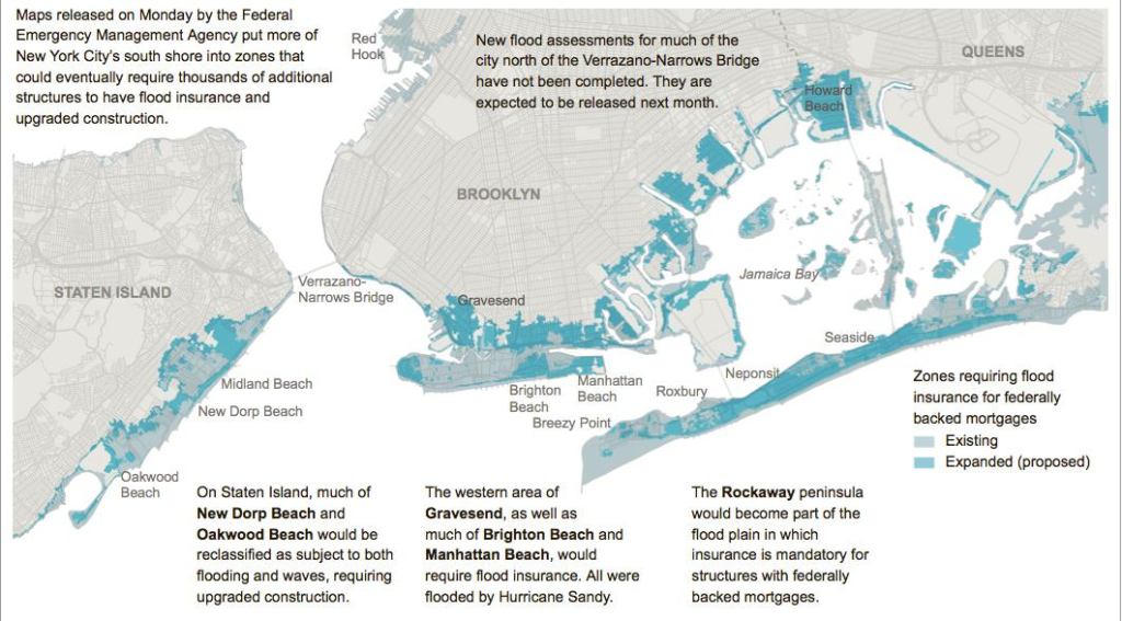
Last month, FEMA released new floodplain maps for New Jersey that have changed the game in that state. Now it’s New York’s turn: FEMA’s revised advisory flood maps for the state are out, and as in New Jersey, they depict an environment that is going to make it more challenging to build, repair, or renovate homes near the water.
The New York Times has this report: (“Twice as Many Structures in FEMA’s Redrawn Flood Zone,” by Cara Buckley). “The maps will not formally go into effect for about two years, but the mayor’s office was already preparing an executive order to help owners of damaged homes rebuild to higher standards,” writes the Times. “That means that a badly damaged home that was not in the old flood zone, but is in the new one, would be allowed to rebuild to prepare for dangers predicted in the new maps. For instance, a home could be hoisted onto posts or pilings, which might have previously been disallowed because of zoning.”
The Staten Island Advance is also on the story: (“The new normal: Revised FEMA flood maps augur a much different shoreline.”) Writes the Advance: “In the five boroughs and Westchester, the new flood zone maps encompass 70,000 buildings, twice as many as were included in previous maps. And a new designation, Zone V, has been established to cover homes that the feds consider vulnerable to violent wave action in addition to flooding.”
The New York Daily News chimes in: (“FEMA releases new flood maps showing 35,000 more New York City, Westchester buildings at risk,” by Christina Boyle and Erin Durkin). “People whose homes are in the flood zone will have two years to elevate their buildings to protect them from surging seawater or begin to face huge spikes in their flood insurance premiums,” explains the News. Said FEMA official Mike Byrne: “We are really committed to . . . building back in a way that it doesn’t get damaged again. If you want to take on more risk, your premiums are going to be more expensive.”