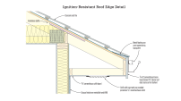
The Federal Emergency Management Agency (FEMA), which administers the National Flood Insurance Program (NFIP), has been working for years to revise its official maps delineating the nation’s floodplains (the Flood Insurance Rate Maps, or FIRMs). Produced by a complex process that combines laser-beam measurements of ground elevation with computer modeling of potential water flows, the maps are used to determine the required elevation for new construction and major remodeling in the floodplain. The rate maps are also the basis for determining any given building’s insurance premiums under the NFIP: buildings that sit three feet above the Base Flood Elevation (BFE) have relatively low premiums, while buildings with occupied floors below the BFE in a flood zone prone to wave action (the “V Zone”) can have premiums running to $10,000 per year. And a new Federal law intended to put the insurance program on a better financial footing takes effect, those rates are only going to go up — in some cases, doubling the premiums for a building even before the new rate maps are taken into account.
So when FEMA introduced its revised floodplain maps for the Jersey shore (still in preliminary, advisory form), local homeowners and politicians were shocked. The revised maps place thousands of homes in newly drawn flood zones — and the elevation requirements for many areas already in the floodplain have gone up by several feet. Local officials have a hard time believing it.
James J. Byrnes, Township Council President in Berkeley, N.J., described FEMA’s advisory base flood elevations for his town as “nuts,” reports the Berkeley Patch (“New FEMA Flood Maps Could Be As Devastating As Superstorm Sandy, Township Officials Say,” by Patricia A. Miller).
Berkeley’s Mayor, Carmen F. Amato, says, “We have over 4,000 waterfront homeowners. Over 40 percent will be affected one way or another. We don’t agree with them. We don’t want to have lagoon homes in Bayville that would be in the same flood zone as the Outer Banks. It just doesn’t make sense.”
And members of the New Jersey Legislature are taking up the call, reports the Newark Star-Ledger (“Democratic senators slam DEP for adopting FEMA’s new flood elevation regs,” by MaryAnn Spoto). Because the maps are advisory and have not been finalized, local and state politicians have the hope that the final maps may cover less area or require lower elevations. “The state’s quick adoption of FEMA’s advisory flood maps was sharply criticized Monday by Democratic state senators who said some residents will needlessly spend tens of thousands of dollars to raise their homes to standards that could be eased,” the paper reports.
But if they want to contest FEMA’s scientific conclusions, locals are in a tough spot. FEMA can’t require towns directly to impose the new elevation requirements; but adopting zoning rules that enforce the FEMA maps is a precondition for participating in the FEMA-backed National Flood Insurance Program (the only flood insurance available anywhere in the United States). In other words, towns are free to ignore FEMA’s advice if they so choose; but in that case, nobody in the town can buy flood insurance protection in case FEMA turns out to be right and the predicted flood does come along some day.
After some back-and-forth with the agency, the town of Toms River decided against asking FEMA to go back and reconsider its designation putting Ortley Beach in the official V zone, reports the Ocean County Signal (“Toms River Adopts Resolution Supporting Residents’ Right to Appeal FEMA Flood Maps”). “FEMA representatives have advised the Township that the ABFE maps are ‘conservative’ and that the current designation in Ortley Beach as shown on the ABFE maps is not likely to change,” the town announced. But the town council has a fallback position: they’re asking for residents to be allowed to appeal the flood zone designations for individual properties, even before the maps take official effect. “The Toms River Township Council adopted a Resolution on Monday February 12, 2013, supporting United States Senators Lautenberg and Menendez in their effort to give homeowners the right to appeal their flood designation under the Advisory Base Flood Elevation Maps (ABFE) instead of waiting until the revised maps are issued in August of 2013,” the town announced.
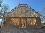
As the new rate maps take full legal effect and the steeper premium structure is phased in, the cost of owning and insuring a beachfront home will be significantly increased. In addition, new houses, or homes that require storm repairs costing more than 50% of the house’s pre-storm value, will have to be elevated above the new BFE — also a significant expense. The North Jersey Record took a look at that issue on February 10 (“New maps complicate flood victims’ rebuilding plans,” by Rebecca D. O’Brien).
“Do we have to rebuild our home? Or spend $100,000 to raise it? Or spend $30,000 more on flood insurance? Common sense tells me that doesn’t make sense,” Moonachie, N.J. homeowner Michael Meehan told the paper. “Where am I going to get that money?”
“Everything is happening at the same time,” said John Miller of the New Jersey Association for Floodplain Management. “When you run the numbers, that makes a huge difference for people every year.”
Facing those prospective costs, some New Jersey shore homeowners are ready to call it quits, reports the Star-Ledger (“Damage from Hurricane Sandy spurs some Jersey Shore homeowners to sell,” by Erin O’Neill). “Some homeowners grappling with the cost of repairing their homes — and rebuilding to new federal height regulations — are hoping someone else wants to buy their slice of the shore,” the paper reports. “But residents deciding to leave now expect to sell their homes for a fraction of what they were worth before the storm.”
For now, life is fraught with uncertainty. And that may mean that the wisest course is to wait, some observers argue. Ocean City realtor Michael McMahon made that argument to the Lacey Patch (“Elevating Homes After Sandy: ‘Wait-and-See Approach Is Prudent’,” by Douglas Bergen). It’s too soon to be sure what flood zone your property will fall into, what the required elevation may be, and what would be your cost to elevate, says McMahon: “People are getting very upset over a lot of possibilities and a lot of unknowns. We believe a wait-and-see approach is prudent.”