Think of the atmosphere as a dynamic mass of air with pockets at different pressures and rivers of air currents holding different amounts of moisture. Wind is air movement between areas of two different atmospheric pressures, flowing from an area of high pressure to an area of low pressure. As water temperatures in the Atlantic warm, minor tropical disturbances — pressure imbalances that create flurries of wind and rain — form, but with very little organization. Such disturbances of slightly higher intensity, known as tropical waves — a low-pressure atmospheric front — blow from the coast of Africa over tropical waters in summer, and bump into similar disturbances in the Atlantic in the intertropical convergence zone (ITC), then drift slowly toward the United States. From June through October, many such pressure disturbances form in the western Caribbean and are pulled northward toward Florida.
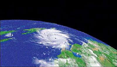
A hurricane is composed of a series of thunderstorms organized into rainbands on its outer edges. Air spirals in toward the center in a counterclockwise pattern and out the top in the opposite direction. Because hurricanes always spin counterclockwise, the winds are always stronger on the right, as the forward speed of the entire storm adds to the speed of the revolving hurricane.
Birth of a Tropical Cyclone A tropical wave can gather into a tropical cyclone as heat and energy are gathered from the atmospheric wave’s contact with the warm ocean waters. The winds near the ocean surface spiral into the disturbance’s low-pressure zones. The warm ocean waters add moisture and heat to the air, which rises. As moisture condenses into drops, more heat is released, contributing additional energy, forming bands of thunderstorms within the cyclone. At this point, the storm is classified as a tropical depression — an organized system of clouds and thunderstorms with a defined circulation and sustained winds up to 38 mph. As the storm gathers, its cloud tops rise higher into the atmosphere, and if the upper level winds remain relatively light (with little or no wind shear), the storm is not dispersed and continues to strengthen into a tropical storm — officially explained as an organized system of strong thunderstorms with a defined circulation and maximum sustained winds of 39 to 73 mph.
The Eye of the Storm
A tropical storm becomes a true hurricane when the winds reach a minimum of 74 mph. At wind speeds of about 80 mph, a distinct “eye,” or “chimney,” appears when the rapid drop in pressure created by the swirling winds forms at the center of the storm. The drop in pressure pulls in warm moist air from hundreds of miles around and causes the center temperature to rise at an even steeper rate, accelerating the evaporation of moisture from the ocean surface. This moist air is carried thousands of feet up the chimney, where it is spewed out in the cold, dry air high above, forming an even greater mass of moisture-laden clouds. Round and round, and up and down, this transfer of energy perpetuates the cyclone generator.
Storm’s End
Landfall typically shuts off the hurricane’s main moisture source, and the surface circulation is often reduced by friction when it passes over land. Moving over cooler water may also rob the storm of energy, or wind shear may tear it apart. However, the remnants of a weakening hurricane can still cause considerable damage, and can always re-intensify if it moves to more favorable regions.
— Clayton DeKorne (adapted with permission from “Hurricane Basics” http://hurricanes.noaa.gov/prepare)