by Clayton DeKorne
It could be a Ford F250 Crew Cab or a Dodge 2500 Ram Van. You’ll know it by the bright orange, 5,500-pound trailer in tow, and the mad glint in the driver’s eyes. As the rig pulls up in a coastal neighborhood, the yellow-slickered agents spilling out aren’t exactly Ghost Busters, but they do intend to capture accurate wind data by erecting a portable weather station. In less than half anhour, the crew will erect a 33-foot steel-lattice tower sporting an array of whirligigs— anemometers capable of measuring gusts traveling up to 200 mph — anda bank of weather sensors. They will fire up a generator, which powers a linked uninterruptible power supply, then boot up the rig’s computer, which will send real-time measurements of the storm over the Internet to meteorologists from the National Oceanic and Atmospheric Administration (NOAA) and analysts contracted bythe Federal Emergency Management Agency (FEMA). With one last look to make sure all systems are go, the researchers will speed off, keeping their fingers crossed that there might still be time to erect another tower before the storm makes landfall.
During a guster, this scenario is typical for the crews working on the Florida Coastal Monitoring Project (FCMP), a collaboration of students and professors from the University of Florida, Florida Institute of Technology, ClemsonUniversity, and Florida International University seeking to quantify near-surface hurricane behavior and to evaluate the actual loads on residential buildings. Theproject includes 32 homes that have been outfitted with instruments to measure windpressures in single-family homes. Instruments on six of these homes standing inthe paths of Hurricanes Frances and Ivan measured — for the first time ever— the true impact of hurricane-force winds.
In less than half an hour, a tower is up and ready to send real-timeweather data direct from a neighborhood in line with a hurricane.
“It’s the first real look we’ve had,” says Forrest Masters, an assistant professor of civil engineering at Florida InternationalUniversity who heads the tower-erection teams. Prior to FCMP’s first deployment,hurricane information was gathered primarily from stations at inland airfields oron offshore buoys. Or, it’s been gathered by reconnaissance aircraft flyingmiles above the storm. However, the peak pressures that load a house are deeply sensitive to ground-level turbulence, which depends on the roughness of the terrain,explains Masters. Wind traveling over the smooth surface of an airfield, or over the ocean, behaves very differently than wind moving over and around the trees andhouses in a neighborhood.
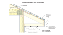
The project includes installing sensors housed in protective aluminum pans to measure wind pressures on critical areas of a roof.
The FCMP studies may have a profound impact on our understanding of how homes perform in hurricanes. The loads referenced in current building codesare based on the analysis of winter storms and thunderstorms, which Masters saysmay be very different animals. New data may give engineers a fine-grained view ofthe gusts spawned by hurricanes, which in turn may suggest new hurricane-resistant building practices. If anything, coastal codes may get stricter: Preliminary datasuggest that tropical cyclones are much “gustier” than storm models basedon winter storms and thunderstorms. — Clayton DeKorne