by Ted Cushman
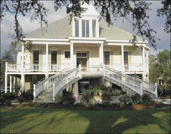
Justine, a plantation home moved to Lakeshore Drive in Mandeville, La., sits on a new 15-foot pier foundation. The renovated home was one of the few lakefront buildings to survive the surge rushing over the seawall when Katrina struck.
The storm surge washing over a 6-foot seawall on the north shore of Lake Pontchartrain packed nothing like the destructive punch of the 25-foot wall of water that scoured beaches and obliterated houses on Mississippi’s Gulf Coast, a scant 90 miles away. Even so, the Pontchartrain wave took its toll on August 29, 2005. From where I stood just two weeks after the storm, I could see homes and storefronts that had been battered into scrap up and down Mandeville’s Lakeshore Drive. By then, light traffic had begun flowing across the causeway past a now-quiet lake. The silence in the nearly deserted neighborhood was interrupted only by the occasional squawk of a utility truck’s two-way radio as a lone crew worked to patch in power.
No Chip off the Block
Amid the near-total ruin along Lakeshore Drive, one person worked determinedly in the heat, loading small bits of debris into a wheelbarrow. I mistook Clayton J. (“Chip”) Borne III for a worker getting started on rebuilding the neighborhood, but he promptly corrected me: “I’m an attorney. A paranoid, compulsive attorney.” And he was happy to report how he insisted on having his house “overbuilt” — as some might have called it before the storm.
Unlike the totally wrecked structures on either side, Borne’s house — which was originally built in the 1840s — was essentially untouched by the storm’s wave, estimated to be more than 10 feet high (Figure 1). He would be able to move back in as soon as crews brought power to the site.
Figure 1. Originally built in the 1840s, the Borne residence (above) suffered only minor damage during Hurricane Katrina. Wind damaged an upstairs window, and the surge washed out the stair railings, but otherwise the home stood firm. Unfortunately, homes on either side of it (bottom photos) did not fare as well.
The house, Borne told me, had been renovated just a year earlier: “We took off everything that was sawn lumber and round nails, right down to the hewn beams and square nails.” The building was stripped to its original framing, resided, the roof rebuilt and covered with new slate, and — most important in terms of simple survival — the whole house elevated to 17 feet above sea level (see “Flood-Proofing Basics” at the bottom ).
Borne pointed to the mark where the floodwaters had peaked, 18 courses of brick above the slab-on-grade floor under the house. Breakaway wall partitions between the brick arches, lightly pinned with plastic fasteners, had done their job; so had the steel- and concrete-reinforced piers behind the brick facade (Figure 2). “I told our mayor, ‘These rules y’all have are a pain, but they work!’ ” Borne exclaimed. “It costs more to do it this way, but it’s cost effective.”
Figure 2. The grid work of steel beams used to lift the Borne house remained in place, posted on steel columns encased in concrete. Initially, the city balked over whether the brick infill arches would provide sufficient clearance for the surge, but eventually allowed them. Katrina affirmed the decision.
Architect Lynn Mitchell, who designed the restoration work and an addition on the house’s north side, later told me the original 1840s structure didn’t need much reinforcing. “It was already pretty rugged,” Mitchell explained. Heavy post-and-beam timbers were connected by pegged mortise-and-tenon joints, and the spaces between the posts were filled in with brick, a traditional French Colonial method known as brique entre poteaux (“brick between posts”).
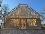
To lift the building, house movers assembled a steel I-beam frame bolted under the original heavy sills and floor girders. The steel frame stayed in place as part of the new structure, with the I-beams bolted to 5-inch concrete-filled pipe columns set on concrete spread footings. The pipe columns themselves, their feet poured into a new slab floor, were then buried within reinforced-concrete brick-faced open-arch walls. In line with each column, steel hurricane straps were fixed to the original timbers and into the addition walls and new roof framing, creating a continuous bearing path for wind uplift loads.
Justine
A few houses down from the Borne residence sits another recent Lynn Mitchell project, the Justine plantation house (lead photo). Relocated from its original site on a bayou plantation (Figure 3), this building had been floated to Mandeville on a barge over Lake Pontchartrain (Figure 4) and placed on a new foundation on Lakeshore Drive, where it now holds offices (Figure 5). “That one did even better than Chip Borne’s house,” Mitchell said. “It wasn’t touched. Justine has become the poster child for FEMA around here.”
Figure 3. Originally built on a plantation on Bayou Teche in 1822, Justine was first renovated in the 1840s. In 1965, the house was moved by barge 65 miles south across the bayou to a site near New Iberia, where it is as shown here (at right) just before it was bought in 2001 and then again moved, in 2003, by barge (below), up the canal and over Lake Pontchartrain to Mandeville.
Figure 4. On its way to Lake Pontchartrain and eventually to its resting place on Lakeshore Drive in Mandeville, Justine, supported on a grid of steel, is pulled upriver on a barge (top). At the Mandeville seawall (bottom), the entire home is rolled off the barge and towed across the street to the corner of Gerard Street and Lakeshore Drive.
“Actually, it was touched,” jests Michael O’Brien, the general contractor on the project. “It kissed the ceiling underneath and knocked a couple of ceiling boards out. But yeah, it was basically untouched.”
Figure 5. Justine now sits on steel piles. The majority of the pilings were encased by concrete masonry units to FEMA specification (top and bottom), then stuccoed. In front, behind the stairs, tapered columns were constructed of brick and then stuccoed using a 2×4 as a screed and an adjustable metal ring as a template. The finished columns can be seen in the lead photo (page 2).
I had caught up with O’Brien by phone, eager to learn what he thought of the latest state rulings: On November 21, 2005, Louisiana lawmakers overwhelmingly approved a bill mandating a statewide construction code. They did not adopt specific building standards but simply established a code council with the authority to adopt the latest standards recommended by the International Code Council. The state had already adopted the 2003 International Building Code in December 2004. Would the change affect the way O’Brien works, I wondered?
Probably not much. O’Brien pointed out that elevated foundations have been required in St. Tammany Parish, La., since 1978. The area has been on the federal disaster radar since Hurricane Betsy roared through in 1965, bringing its own 10-foot wave that swamped Mandeville as well as New Orleans. Betsy had been the worst flood disaster since the hurricane of 1947 and the first United States hurricane to produce more than $1 billion in damages. Since “Billion-Dollar Betsy,” St. Tammany Parish has received 16 Presidential Disaster Declarations, more than any other parish in the state.
Repetitive flooding hazards prompted Mandeville to institute basic flood elevation requirements in 1978 to conform to FEMA’s guidelines for storm-resistant construction, in compliance with the National Flood Insurance Program. This meant that anyone wanting flood insurance had to comply with city rules.
“I remember those rules biting me almost 30 years ago,” recalls O’Brien. “The clients wanted their house 3 feet off the ground, and the building inspector came along and shut the job down. They made us pick it up to 10 feet.”
In 2003, Mandeville adopted a new ordinance that raised the required elevation to between 15 and 17 feet above sea level for all new houses and major renovations on the lakefront. This allowed Mandeville to be reclassified on the Flood Insurance Rating Map, and lowered insurance premiums for area residents.
O’Brien insists that not much has really changed. “We’ve been doing it right all along,” he explains. “This is the suburbs, and to qualify for flood insurance, everybody has known that you have to be elevated on pier foundations. Whether the height is 10 or 17 feet, that is just a detail.”
History Lesson
The key point, observes O’Brien, is a lesson in history. The old-time builders knew what to do all along, and, indeed, today it’s mostly the older historic buildings on the lakefront that have proven themselves most resilient to handle the flood. “Sometime in the 1930s and 1940s they started building low, without even thinking that the lake would get angry,” O’Brien says.
The lake’s anger is clearly evident now up and down Lakeshore Drive, where most houses facing the lake had been Bluto-punched by the wave. When I visited, the guts of each residence lay strewn over the front lawns. Just a block back from the water, few houses showed significant damage. The rest of the town suffered heavy wind damage, mostly from falling trees, but it could have been far worse. Mandeville was on the back side of the storm: “If we had been closer to the eye, we would have lost a lot more houses,” O’Brien notes.
According to O’Brien, present-day requirements for resisting both wind and wave are straightforward: Lift the house and tie it down. “The straps are easy to put on,” he urges. “We have nail guns to do that now.” But as easy as it might be to comply, O’Brien has few illusions about building the totally storm-proof house. “A 100-foot tree falling on a house — you can’t build for that. And some people on the coast had their houses up 17 feet — brand-new houses strapped like crazy. But a 20-foot, 30-foot wall of water came through, and now there is nothing left. The house is just completely gone. You can’t build for that, either.” ~
SPECIFICATIONS FOR MASONRY PIERS IN COASTAL REGIONS
Contributing editor Ted Cushman reported this story while traveling to the Gulf Coast to assist in the aftermath of Hurricane Katrina in September.
Resources
FEMA 55. Based on a large and convincing body of data provided during the unusually active 2004 and 2005 hurricane seasons, homes built to the details specified in the Coastal Construction Manual (FEMA 55) are capable of surviving the most powerful tropical storms. This lengthy and comprehensive document is available free as a printed report (enough to fill a 4-inch binder) and as an interactive CD-ROM direct from the FEMA Publications Distribution Facility, 800-480-2520. FEMA 499. FEMA has also produced a series of 31 fact sheets (FEMA 499) that summarize the basic NFIP regulatory requirements and provide information about proper siting of coastal buildings, protecting utilities, detailing connections, and weatherizing the building enclosure (http://www.fema.gov/fima/mat/fema499.shtm).
Flood-Proofing Basics
In compliance with requirements laid out by the National Flood Insurance Program (NFIP), all buildings in A and V zones must be built above the Base Flood Elevation (BFE). This means that the structural elements of the lowest floor must be elevated above a height determined by a statistical analysis of the last 100 years of flooding. There is no single A- or V-zone requirement used on a nationwide basis. Instead, each local community adopts its own certification procedures and documents, which comply with minimum NFIP requirements.
Wave resistance
Waves exert enormous pressures on buildings. While winds wield pressures in the tens of pounds per square foot, a 2- to 3-foot wave can exert pressures in the hundreds or even thousands of pounds per square foot. A 10-foot wave such as that coming over the Mandeville seawall during Katrina packed several thousand pounds of force per square foot — far higher than any ordinary solid walls could resist. To minimize failure in such an event, the NFIP calls for an open foundation on piles or columns that puts the home above the BFE. This allows the waves to wash harmlessly under the building.
To prevent the foundation from collapsing under the severe lateral force of the wave, no solid structure can enclose the columns; only lattice, screen, or breakaway walls are allowed. In some jurisdictions, even breakaway walls may not be allowed, because they are difficult to monitor after a building is occupied. Owners, anxious to maximize space, often convert enclosed areas into living space by adding wiring, plumbing, countertops, partition walls, and closets — all of which reduce the ability of these walls to break away easily. Instead of breaking free and dissipating the force, the full brunt of the wave is transferred to the columns, increasing the chances that they will buckle.
Load paths
As important as dispersing the force of the waves, the structure above the lowest floor elevation must be designed and constructed to resist flotation, collapse, and lateral movement. Of these forces, lateral movement is perhaps the most likely event because of the extreme wind forces during a hurricane that threaten to push, lift, and overturn the structure. In this case, the primary line of defense is a vertical load path, made with metal connectors to firmly anchor all the structural connections from the foundation columns to the roof.
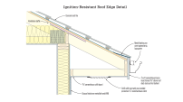
V-ZONE OPEN FOUNDATION
In V zones, the space between ground level and lowest floor elevation must be free of obstructions, including diagonal bracing, equipment, or other fixed objects that can transfer flood loads to the foundation.