New satellites launched in November and December will enhance weather observations and predictions in coming years, helping forecasters better predict and track hurricanes.
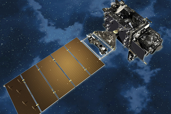
On November 19, NASA launched “GOES R,” the first of a planned set of fourth-generation “GOES” satellites that will supersede existing geostationary satellites with new, better-equipped versions. Named “GOES R” at launch, the new satellite, the size of a city bus, will get the name GOES 16 when it’s placed into full operation.
Twin Cities reporter Brian Lambert reported on the story for MinnPost (see: “Why weather nerds are so excited these days,” by Brian Lambert). “One part of the package, called the Advanced Baseline Imager, will more than double the resolution of current NOAA satellites, many of which have already reached the end of their effective life-spans,” MinnPost reported. “The ABI (in NASA-speak) can scan the whole hemisphere in five minutes, and if it detects a particularly dangerous weather pattern developing, its handlers will be able to scan a smaller slice of territory every 30 seconds. The ‘camera’ system is so powerful it will return images with a resolution of 0.3 to 1.2 miles across the entire western hemisphere. Once locked in a geosynchronous orbit 22,300 miles up, one gushing reviewer described it as ‘like [being able to see] the ridges on the side of a quarter located a mile away.'”
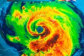
With a view of the entire continental U.S., as well as oceans off both coasts, GOES 16 will provide information on ocean storms as well as tornado outbreaks, rainstorm fronts, and blizzards. The new satellite’s finer resolution and shorter time window will extend the warning time for tornadoes and flash flooding by critical minutes, according to the report.
This week, NASA launched another fleet of eight suitcase-sized low-orbit weather satellites — much smaller, simpler, and cheaper than the sophisticated GOES satellite, but able to supply crucial weather data for hurricane forecasting. Science Magazine had a report (see: “NASA microsatellite mission could breathe new life into hurricane prediction,” by Paul Voosen).
The eight satellites in the Cyclone Global Navigation Satellite System (CYGNSS) will read the radio transmissions from existing GPS satellites, after the GPS radio waves bounce off the ocean surface. “The long radio wavelengths of GPS signals, continuously emitted from a constellation of satellites in medium-Earth orbit, can pass through heavy rain—one reason your phone can easily locate you in a storm,” Science explained. “By gathering up these GPS signals after they bounce off the ocean, CYGNSS can measure the surface roughness of the sea, which in turn can be used to calculate wind speeds. Typical weather satellites can’t do the job because they rely on microwave-based sensors, which get scrambled by rain.”
While weather forecasters have significantly improved their ability to forecast a storm track, their ability to predict a storm’s intensity has lagged behind. This new data should help with that goal, according to weather experts.