When FEMA finally released new working versions of its proposed flood maps for the New Jersey coast last month, many property owners on the barrier islands and bay shores were relieved. Along the shoreline, thousands of properties had been moved from the high-hazard V Zone to the less-severe A Zone. And in many cases, Base Flood Elevation (BFE) levels had also dropped.
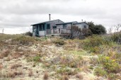
Great news for many homeowners — but not for all, reports Phildadelphia TV station NBC10 (“Shore Home Gets Short End of Stick on New Flood Map,” by Tracey Samuelson/NewsWorks.org). Attorney Ken Wilbur was “stunned” to find that his Manasquan vacation home had moved the other way. “His vacation home in Manasquan moved from an A-zone, where it’s recommended he jack up his home ten feet above sea level, to a V-zone, where he’s deemed to be at risk for flooding plus damage from three-foot-high waves,” the station reports. “FEMA now recommends that his home should be elevated 14 feet above sea level and placed atop expensive pilings. Not complying with these recommendations means his annual flood insurance bill could climb to tens of thousands of dollars.”
The reason? “In very rare cases along the coast, the V-zones did grow, largely because the December maps didn’t include modeling of how waves move over land, or information on coastline and dune erosion. ‘That erosion of those primary frontal dunes, after it was analyzed, increased certain areas,’ said FEMA official Bill McDonnell. ‘So it was showing that the existing dunes were not showing as much protection as we estimated [in December].’ FEMA estimates this affects less than one percent of New Jersey’s coastal flood plain area — meaning Ken Wilbur is truly a special case.”
Wilbur has already invested big dollars into repairing and upgrading his house, based on the assumption that the house would stay in the A Zone. Now he regrets the choice, saying: “I don’t know that I would have put $100,000 into this house the way it is now, if I had known that I was going to have to lift it up to a V-zone.”