East Coast residents are accustomed to hurricane hype. This Monday, however, Hurricane Sandy has been living up to the hype — and then some. The storm’s winds intensified as Sandy headed north and began to swing westward toward the shore, the Washington Post reported on the Post’s “Hurricane Sandy: live updates” page.
But Sandy’s winds, while increasing in power, were still less fearsome than the massive slug of water the gigantic storm was pushing ahead of it. Many hours before a projected 6 PM to 10 PM landfall on the southern New Jersey shore, Hurricane Sandy’s storm surge was already doing damage along the waterfront. Wrote hurricane expert Jeff Masters in a Weather Underground blog post (“Superstorm Sandy intensifying, bringing record storm surges“): “It is clear that Sandy is not going to pull its punch, and this superstorm is going to deliver a punishing multi-billion dollar blow to a huge area of the Eastern U.S.”
Atlantic City, N.J., was flooded by mid-day, reported WABC-TV Eyewitness News-7 (“Sandy breaching New Jersey beaches; AC under water“). “Atlantic City’s public safety director says most of the city is under water,” the station reported. “Willie Glass says the city is basically flooded and it looks like the damage will be worse than the storm of 1962. Fire officials in Pleasantville report at least two rescues from homes surrounded by water and two more rescues are under way.” State officials have asked 115,000 barrier island residents to evacuate, the report says.
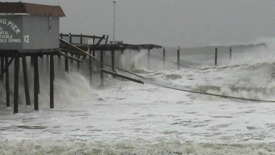
In Ocean City, Md., waves snapped a fishing pier (see photo).
High Tide
And this is just the beginning. Sandy’s landfall Monday evening is slated to coincide with a 9 PM high tide. Full moon effects will add several inches to that tide, says Jeff Masters. In New York City, the risk is major. “Sandy’s storm surge will be capable of overtopping the flood walls in Manhattan, which are only five feet above mean sea level. On August 28, 2011, Tropical Storm Irene brought a storm surge of 4.13′ and a storm tide of 9.5′ above MLLW to Battery Park on the south side of Manhattan. The waters poured over the floodwalls into Lower Manhattan, but came 8 to 12″ shy of being able to flood the New York City subway system. According to the latest storm surge forecast for New York City from NHC, Sandy’s storm surge is expected to be 10 to 12′ above MLLW. Since a storm tide of 10.5′ is needed to flood the subway system, it appears likely that portions of the NYC subway system will flood. The record highest storm tide at The Battery was 10.5′, set on September 15, 1960, during Hurricane Donna.”
With millions turning to the web for news, The New York Times and the Wall Street Journal have taken down the “paywall” that requires readers to register and pay to read the publications online. Today’s New York Times coverage is here: (“Storm Gains Strength as It Churns North,” by James Barron and Brian Stelter). The Journal’s lead story is here (“East Grinds to Halt as Sandy Strengthens,” by Mike Esterl, Ted Mann, Lisa Fleisher, and Jenny Strasburg).
“New York officials closed down public transit Sunday evening, a bus- and rail-system that normally ferries about 8.5 million passengers a day during the workweek,” the Wall Street Journal reported. “New York city schools, which serve more than a million students, also were ordered shut until the storm cleared. New York Mayor Michael Bloomberg told an estimated 375,000 residents to leave flood-prone neighborhoods in Brooklyn and Manhattan.”
Moving Inland
On Tuesday and Wednesday Sandy will move slowly inland, bringing rain to most of the Northeast and snow to higher elevations. In upstate New York, authorities are mainly concerned about the storm’s high winds, however, the Albany Times-Union reports (“Winds pose main threat,” by Bryan Fitzgerald). “Come Tuesday morning, tens of thousands of homes and businesses could be without power, meteorologists, National Grid and public officials said.”
In West Virginia, the storm’s rains will turn to snow at higher elevations, reported the Charleston Daily Mail (“3 feet of snow possible, blizzard warning expanded,” Associated Press). “Forecasters Monday upgraded the amount that could fall along the state’s highest ridge tops to as much as 3 feet, although most residents will see nothing close to that much,” the paper reported.
Coastal Connection reached Rehoboth Beach, Del., builder Patricia McDaniel at 1:30 Monday afternoon. McDaniel’s Facebook page for her company, Boardwalk Builders, has a set of photos she posted this morning, showing the condition of roads near the water.
“If you didn’t know what was coming, you’d think it was just a rainy day and you’d go out shopping,” said McDaniel. “But if you went down to the shore, you’d know it. I don’t have a lot of direct information about what’s happening right now on the coast itself, because they kicked me out. But right now the Weather Service buoy in the harbor, which I can check on line, shows winds at 40 mph, gusting to about 45.”
McDaniel posted links on her Facebook page to several local webcams located near the shore. By this afternoon, she said, many of the webcams wouldn’t load any more. “But I looked at one that’s near the road along the peninsula, on the ocean side of the Indian River inlet south of Rehoboth,” she said, “and you can’t see the road.”