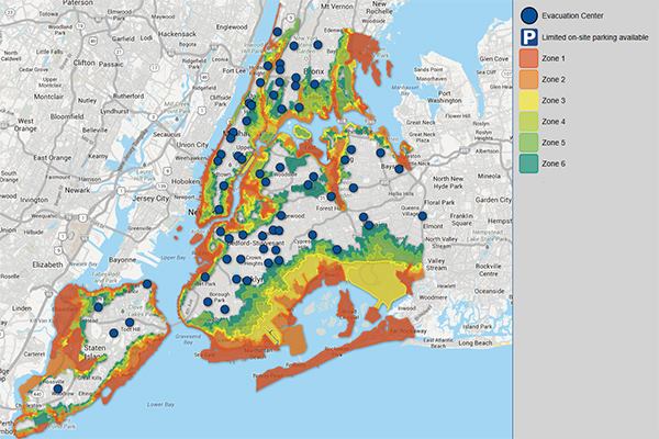
Hurricane Sandy’s storm surge flooding killed 43 people in New York City, and hundreds more had near escapes from death. Now, with the new hurricane season beginning, city officials have updated their plans for evacuating vulnerable neighborhoods in the event of another storm,.the Huffington Post reports (“NYC Hurricane Evacuation Zones Map Updated Months After Hurricane Sandy“).
According to a city press release, 37% of New York’s residents now live in one of the official evacuation zones (“Final Updated Hurricane Evacuation Zones Announced“). “The new zone system was developed using the latest Sea, Lake, and Overland Surges from Hurricane storm surge inundation maps generated by the National Weather Service and processed by the US Army Corps of Engineers,” the city says. “The zones are based on coastal flood risk resulting from storm surge, the geography of the low-lying neighborhoods, and accessibility to these neighborhoods by bridges or roads.” New Yorkers with Internet access can check the city’s “NYC Hurricane Evacuation” website to familiarize themselves with the map or, as a storm approaches, to learn whether their neighborhood is under evacuation orders.